Understanding Geohashing: A Comprehensive Guide
- Understanding Geohashing: A Comprehensive Guide
What is Geohashing?
Geohashing is a method for encoding geographic coordinates (latitude and longitude) into a short string of letters and digits. This encoded string, called a geohash, offers a compact, human-readable way to represent geographic locations. Developed by Gustavo Niemeyer in 2008, geohashing is widely used in geographic information systems (GIS), spatial databases, and location-based services.
Why is Geohashing Required?
Advantages of Geohashing
Compact Representation:- Geohashes condense geographic coordinates into a short string
- This makes them easier to store and communicate
Spatial Locality:- Geohashes maintain spatial locality, meaning that points close to each other geographically will have similar geohashes
- This is crucial for efficient spatial querying and indexing
Hierarchical Structure:- Geohashes provide a hierarchical structure where each additional character increases the precision of the location
- This allows for variable levels of granularity in spatial data representation
Efficient Querying:- Geohashes enable efficient spatial queries, such as finding all points within a certain area or bounding box
- This is especially useful for applications like geocoding, mapping, and location-based services
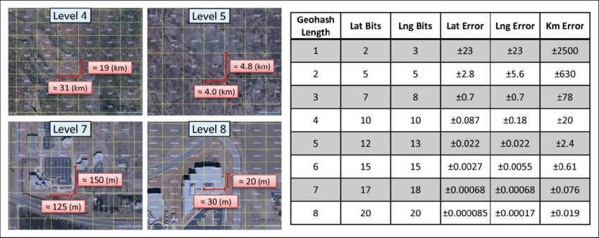
Understanding Geohash Precision
Precision in geohashing refers to the accuracy of the geographic location represented by the geohash.
The length of the geohash string determines its precision: longer geohashes correspond to smaller areas, thus representing locations more accurately.
Here is a table showing the precision of geohashes based on their length:
Geohash Precision Table
| Geohash Length | Latitude Bits | Longitude Bits | Cell Width | Cell Height |
|---|---|---|---|---|
| 1 | 2 | 3 | ≤ 5,000 km | ≤ 5,000 km |
| 2 | 5 | 5 | 1,250 km | 625 km |
| 3 | 7 | 8 | 156 km | 156 km |
| 4 | 10 | 10 | 39.1 km | 19.5 km |
| 5 | 12 | 13 | 4.89 km | 4.89 km |
| 6 | 15 | 15 | 1.22 km | 0.61 km |
| 7 | 17 | 18 | 153 m | 153 m |
| 8 | 20 | 20 | 38.2 m | 19.1 m |
| 9 | 22 | 23 | 4.77 m | 4.77 m |
| 10 | 25 | 25 | 1.19 m | 0.596 m |
| 11 | 27 | 28 | 149 mm | 149 mm |
| 12 | 30 | 30 | 37.2 mm | 18.6 mm |
How is Geohash Calculated?
Step-by-Step Calculation Using a 4-Character Geohash
Let’s derive a 4-character (precision) geohash for Google’s headquarters located at approximately latitude 37.422 and longitude -122.084
We’ll break down the process into detailed steps.
1. Convert Latitude and Longitude to Binary
Latitude Conversion
Latitude ranges from -90 to +90.
| Step | Range | Midpoint | 37.422 Comparison | Binary | New Range |
|---|---|---|---|---|---|
| 1 | [-90, 90] | 0 | 37.422 > 0 | 1 | [0, 90] |
| 2 | [0, 90] | 45 | 37.422 < 45 | 10 | [0, 45] |
| 3 | [0, 45] | 22.5 | 37.422 > 22.5 | 101 | [22.5, 45] |
| 4 | [22.5, 45] | 33.75 | 37.422 > 33.75 | 1011 | [33.75, 45] |
| 5 | [33.75, 45] | 39.375 | 37.422 < 39.375 | 10110 | [33.75, 39.375] |
| 6 | [33.75, 39.375] | 36.5625 | 37.422 > 36.5625 | 101101 | [36.5625, 39.375] |
| 7 | [36.5625, 39.375] | 37.96875 | 37.422 < 37.96875 | 1011010 | [36.5625, 37.96875] |
| 8 | [36.5625, 37.96875] | 37.265625 | 37.422 > 37.265625 | 10110101 | [37.265625, 37.96875] |
| 9 | [37.265625, 37.96875] | 37.6171875 | 37.422 < 37.6171875 | 101101010 | [37.265625, 37.6171875] |
| 10 | [37.265625, 37.6171875] | 37.44140625 | 37.422 < 37.44140625 | 1011010100 | [37.265625, 37.44140625] |
Latitude binary: 1011010100
Longitude Conversion (-122.084)
Longitude ranges from -180 to +180.
| Step | Range | Midpoint | -122.084 Comparison | Binary | New Range |
|---|---|---|---|---|---|
| 1 | [-180, 180] | 0 | -122.084 < 0 | 0 | [-180, 0] |
| 2 | [-180, 0] | -90 | -122.084 < -90 | 00 | [-180, -90] |
| 3 | [-180, -90] | -135 | -122.084 > -135 | 001 | [-135, -90] |
| 4 | [-135, -90] | -112.5 | -122.084 < -112.5 | 0010 | [-135, -112.5] |
| 5 | [-135, -112.5] | -123.75 | -122.084 > -123.75 | 00101 | [-123.75, -112.5] |
| 6 | [-123.75, -112.5] | -118.125 | -122.084 < -118.125 | 001010 | [-123.75, -118.125] |
| 7 | [-123.75, -118.125] | -120.9375 | -122.084 < -120.9375 | 0010100 | [-123.75, -120.9375] |
| 8 | [-123.75, -120.9375] | -122.34375 | -122.084 > -122.34375 | 00101001 | [-122.34375, -120.9375] |
| 9 | [-122.34375, -120.9375] | -121.640625 | -122.084 < -121.640625 | 001010010 | [-122.34375, -121.640625] |
| 10 | [-122.34375, -121.640625] | -121.9921875 | -122.084 < -121.9921875 | 0010100100 | [-122.34375, -121.9921875] |
Longitude binary: 0010100100
2. Interleave the Bits
Interleave the bits of longitude and latitude to create a single binary string.
(Longitude, Latitude) -> (01)
| Step | Latitude | Longitude | Interleaved |
|---|---|---|---|
| 1 | 1 | 0 | 01 |
| 2 | 0 | 0 | 0100 |
| 3 | 1 | 1 | 010011 |
| 4 | 1 | 0 | 01001101 |
| 5 | 0 | 1 | 0100110110 |
| 6 | 1 | 0 | 010011011001 |
| 7 | 0 | 0 | 01001101100100 |
| 8 | 1 | 1 | 0100110110010011 |
| 9 | 0 | 0 | 010011011001001100 |
| 10 | 0 | 0 | 01001101100100110000 |
Interleaved binary: 01001101100100110000
3. Convert Interleaved Binary to Base32
The binary string 01001101100100110000 needs to be converted to base32.
-
Pad the binary string to make its length a multiple of 5: The length of
01000110100100110000is 20, which is already a multiple of 5, so no padding is needed. -
Divide the binary string into 5-bit groups:
01001 10110 01001 10000 - Convert each 5-bit group to its decimal equivalent:
01001= 910110= 2801001= 910000= 16
- Map each decimal value to the corresponding base32 character:
Base32 alphabet:
0123456789bcdefghjkmnpqrstuvwxyz- 9 -> 9
- 28 -> u
- 9 -> 9
- 16 -> h
Therefore, the binary string 01000110100100110000 converts to the base32 string 9u9h.
Resulting Geohash
The 4-character geohash for Google’s headquarters (latitude 37.422, longitude -122.084) is 9u9h.
Benefits of Interleaving
Spatial Locality:- Interleaving ensures that geohashes for nearby locations are similar, preserving spatial locality. This is critical for spatial queries and indexing.
Efficient Range Queries:- Interleaved geohashes allow for efficient bounding box queries, which are common in geographic searches. This makes it easier to query all points within a certain area.
Balanced Precision:- By interleaving, both latitude and longitude contribute equally to the precision of the geohash. This avoids skewed precision that could occur if one coordinate is given more bits than the other.
Hierarchical Subdivision:- Interleaving provides a hierarchical structure where each additional character refines the location, allowing for varying levels of granularity.